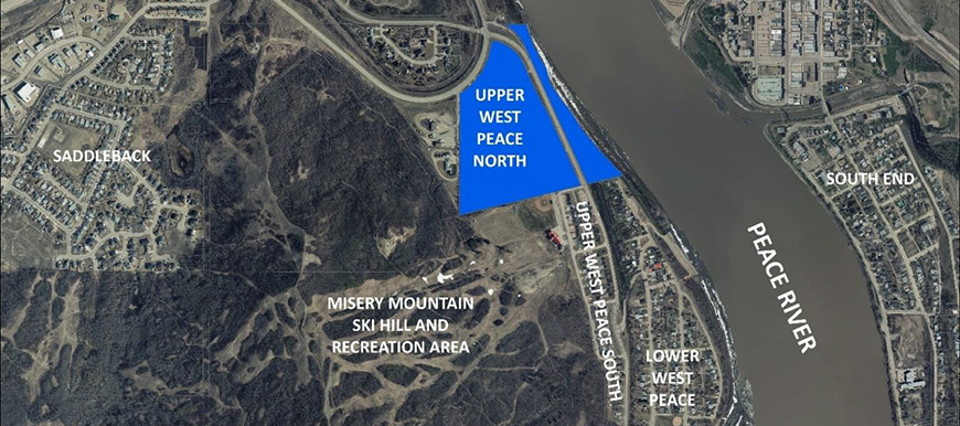
Upper West Peace North Area Structure Plan
Last Updated August 11, 2021
The ASP and related bylaws were adopted by Town Council on August 9, 2021. The ASP document can be found on the Town’s Approved Plans and Bylaws page.
Consultation Report
Consistent with the requirements of the Municipal Government Act, the Upper West Peace North Area Structure Plan has underwent a public consultation process to inform the community and in particular the adjacent neighbourhoods of the plan content, and to provide an opportunity to provide feedback. The consultation process, the feedback received, and changes made to the plan based on that feedback are summarized in the Consultation Report, which can be found here.
Area Structure Plan Next Steps
- The Area Structure Plan was updated based on some of the feedback provided during the consultation process. The updated ASP document can be found here.
- July 2021: The ASP will be presented to Town Council for first reading.
- August 2021: An ASP Public Hearing will be held at a Council meeting.
- August or September 2021: The ASP will be presented to Town Council for second and third reading. COMPLETE
Upon third and final reading of the ASP bylaw, the Area Structure Plan process will be finished. Future subdivision and development will be required to conform to the Plan.
March 18, 2021, Open House
A project open house for both the ASP and the related Shaftesbury Trail Utility Realignment project was held on March 18, 2021. Representatives from the Town of Peace River and Beairsto & Associates Engineering Ltd presented details about the project and answered questions from residents. The video recording of the open house is posted below: The Area Structure Plan was focus of the presentation between minutes 38 and 1:02 of the video.
Shaftesbury Trail Utility Realignment Next Steps
Information about the related Shaftesbury Trail Utility Realignment project can be found at the link below.
A second project Open House will be scheduled in the near future.
Questions?
What’s the point of this plan?
An Area Structure Plan (ASP) lays out how land in a given area will be developed and used. There is currently an ASP in place for this area, called the Citadel Area Structure Plan. However, the Town will be realigning water and sewer lines and needs to update the ASP, so that the utilities and the future development work together.
The new draft Upper West Peace North (UWPN) ASP will allow for the utility installation and will also facilitate a mix of commercial and residential development on the land immediately west of the Shaftesbury Trail
The Town of Peace River worked in collaboration with the landowner through 2020 to draft the new plan.
Project Partners:
What is the process to develop the plan?
The ASP process includes:
| Draft Plan and complete project engineering | January to December 2020 |
| Conduct public consultation and refer draft to relevant Government of Alberta Departments. We are here. | January 2021 to March 2021 |
| Review feedback | March 2021 |
| Finalize Plan based on any feedback | April 2021 |
| Present Plan to Council for 1st reading | April 2021 |
| Advertise and hold Public Hearing | May 2021 |
| Present Plan to Council for 2nd and 3rd reading | May 2021 |
When will development actually happen?
In 2021 and 2022 water and sanitary lines will be installed through the ASP area.
After the utility construction, the Town may at a future date, install a pedestrian trail through the plan area. Any trail development will depend on future budgets and priorities.
The future subdivision and development of the lands including the planning and installation of stormwater infrastructure and the road network (including the road closures) are driven by the private landowner, and there being market conditions to support the development. It is not possible to specify when this development will occur, however, the plan will ensure that when development does happen, it will work with the infrastructure that has been installed.
The Plan specifics:
Vision
The UWPN ASP establishes the following vision.
The Upper West Peace North ASP provides a flexible direction that facilitates the further build out of the Upper West Peace neighbourhood in the Town of Peace River. It provides opportunities for commercial and residential development.
The plan goals and policies are intended to support the implementation of that vision.
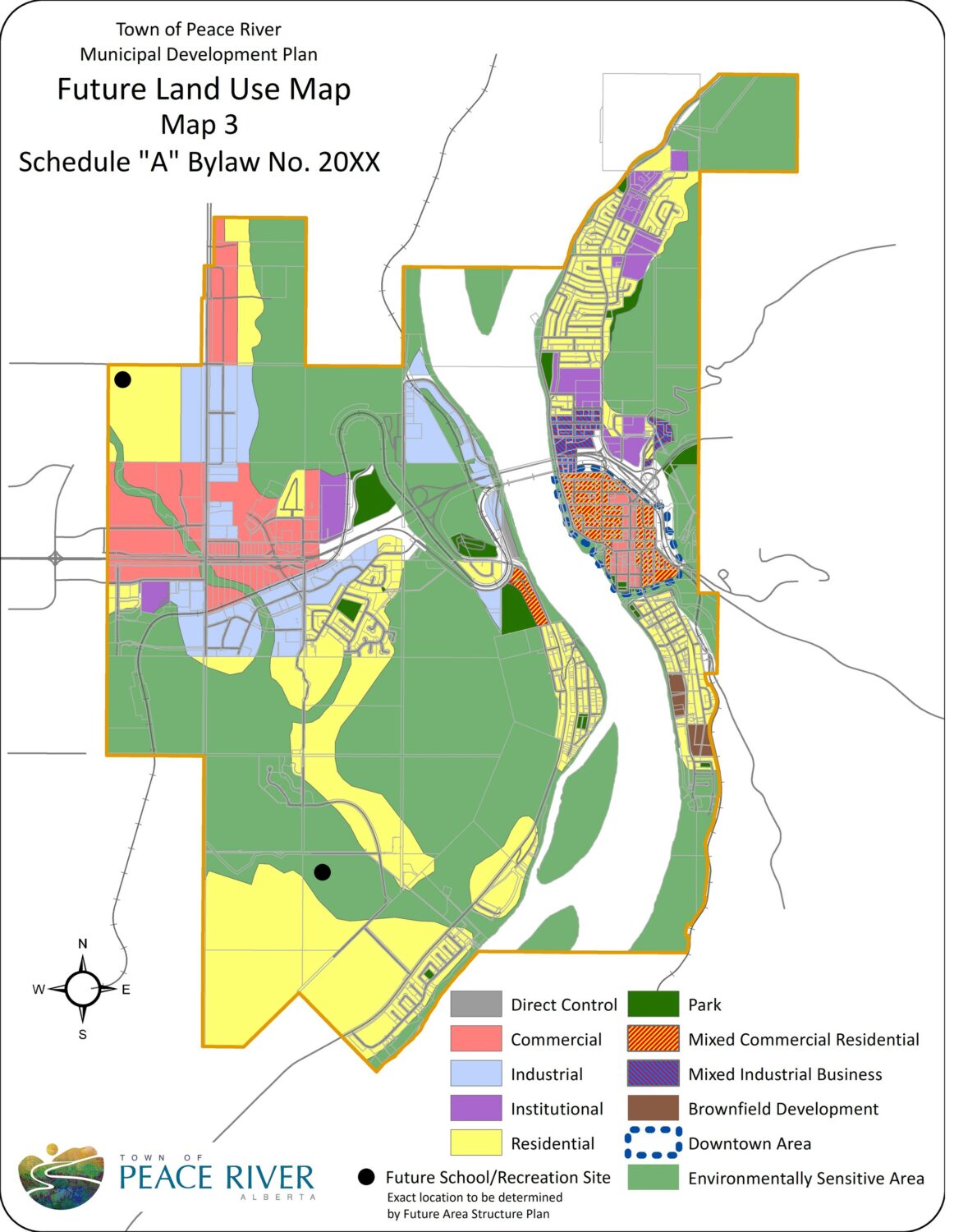
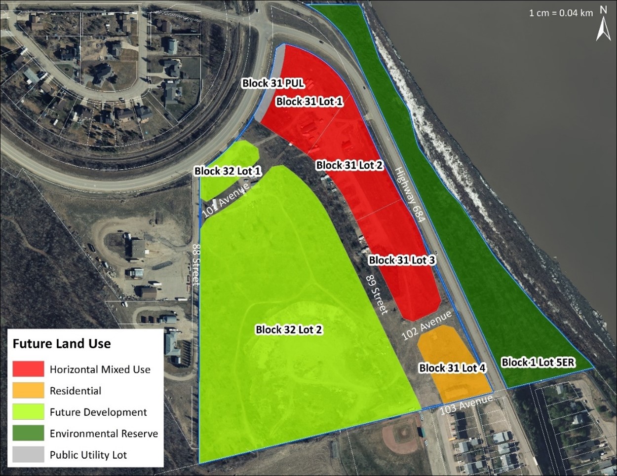
Future Land Use Plan
The Future Land Use Plan prescribes a combination of residential and commercial development that can respond to the demands of the market. Residential lands development may include single detached dwellings – duplex/semidetached – row houses – low rise apartments.
Commercial developments may include restaurants – personal service (e.g. hair salons) – a variety of retail. Development of the Future Development area will require further planning and an amendment to this plan.
Phasing
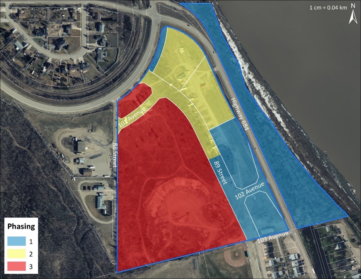
After the utility installation, the plan area will be developed in three phases.
Phase 1 includes the Residential Lot and one Mixed-Use Lot, as well as the road closure at 103rd Avenue and the development of the new 102 Ave access.
Phase 2 includes the two north-most Mixed-Use lots, as well as the road closure at 88 street and the development of new 89th Street access onto old Highway 2, and the development of 101st Ave.
Phase 3 includes the development of the Future Development Area. An amendment to the ASP will be required prior to development.
Transportation Network
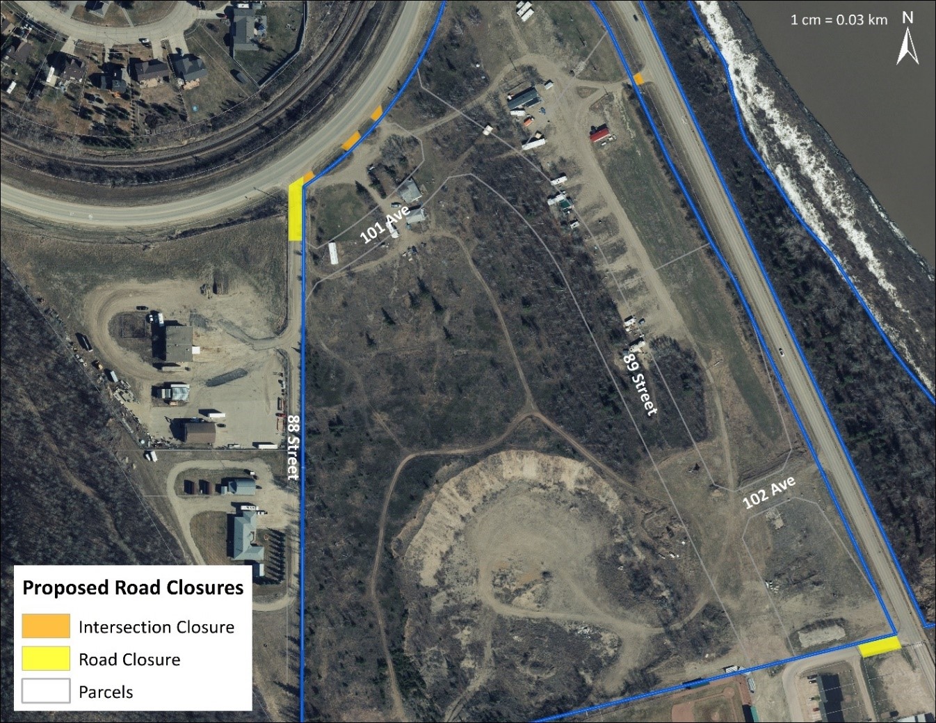
The development of the plan area will impact the existing transportation network in the Upper West Peace area. Specifically, the intersections at 103rd Ave and 88th Street and a portion of each road will be closed, and new intersections at 89th Street and 102nd Ave and associated new roads will provide access into and through the plan area and the existing Upper West Peace neighbourhood.
The road closures are required by Alberta Transportation to ensure the continued safety of the road network along old Highway 2 and the Shaftesbury Trail.
The plan also addresses pedestrian infrastructure through the area and connects to existing and proposed pedestrian pathways.
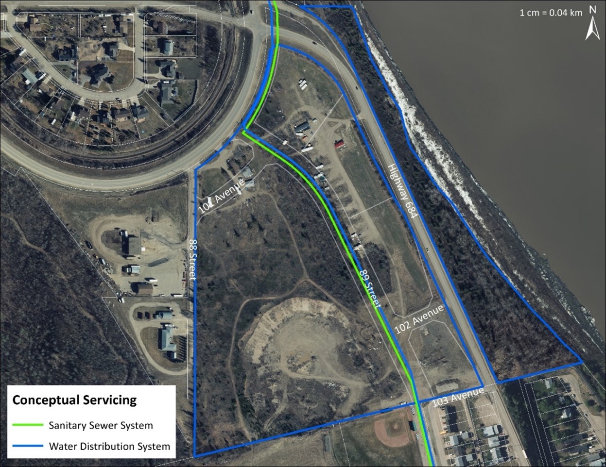
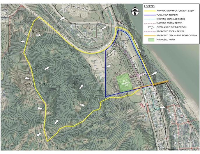
Utilities
Water and Sanitary infrastructure will be installed through the Shaftesbury Utility Realignment Project.
Stormwater infrastructure will be installed, consistent with the Stormwater Management Plan which will be completed prior to subdivision approval.
Accompanying Bylaw Amendments
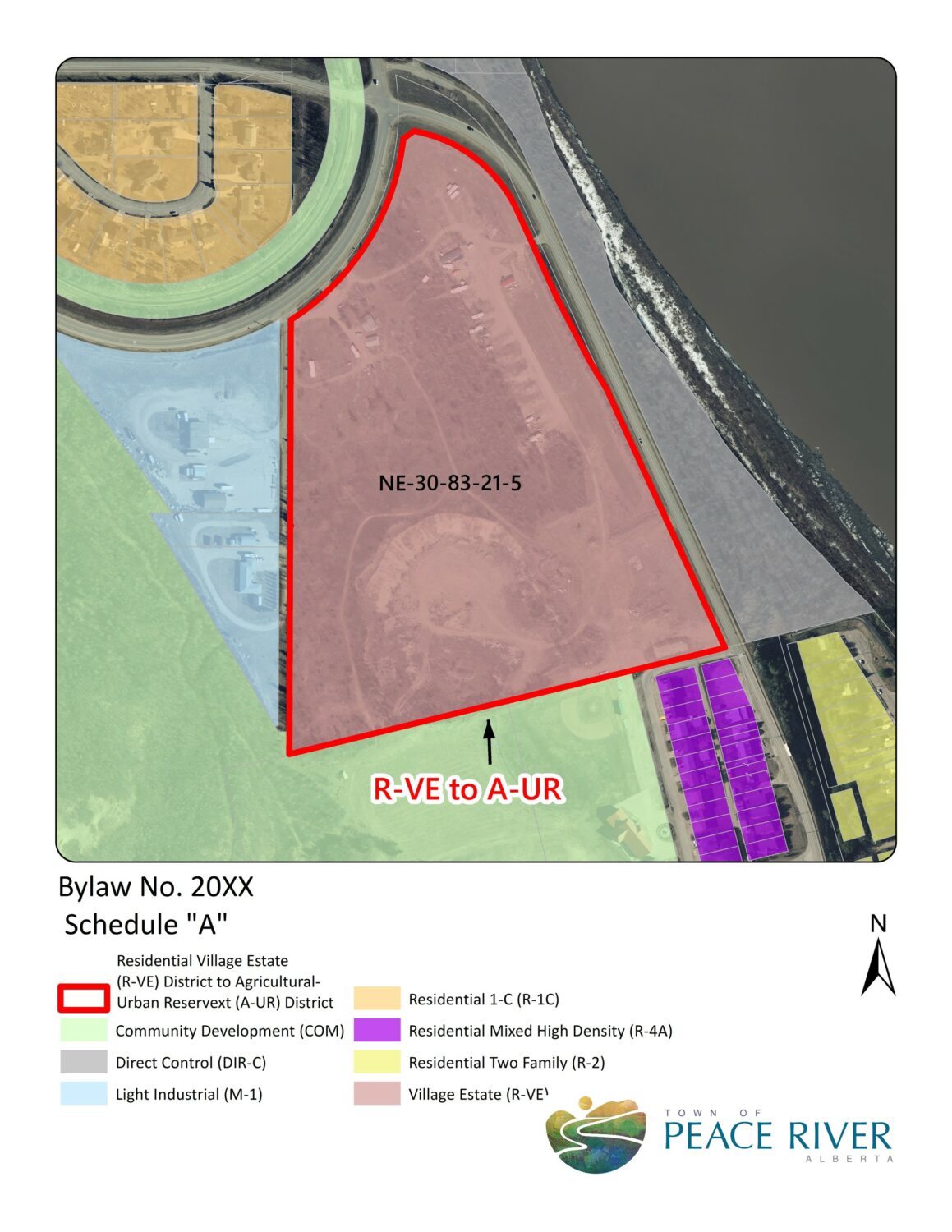
An amendment to the Municipal Development Plan (MDP) and Land Use Bylaw (LUB) will ensure that the Town has a consistent planning framework with the direction established by the ASP, as required by the Municipal Government Act.
The MDP amendment updates the Future Land Use Concept of that plan, to allow for the commercial and residential development of the ASP area. The LUB amendment redistricts the primary plan area to the Agricultural-Urban Reserve district, as recommended by the ASP. This districting will change in the future, prior to the subdivision and development of the lands.
Copies of the draft bylaws are listed below: